Tuesday, 4 March 2014

Metropix makes the shortlist for this years ESTAS!


   Metropix has been shortlisted as a top 10 firm
in the biggest estate & letting agent awards in the UK,  known throughout the industry as THE ESTAS.

Metropix has been recognised for its outstanding customer service to its clients by the largest and longest running award scheme in the UK residential property industry.  THE ESTAS determines the best agents and suppliers in the industry through research carried out amongst customers who are asked a series of questions about the service they have received from their agent or supplier.  This years’ competition saw 32,000 surveys completed.

This year just over 3,000 agents across the UK voted for their favourite suppliers by rating them on the quality of the service they provide and the value each supplier brings to their business.  Just entering this category speaks volumes for the confidence each supplier has in the quality of the products & services they deliver.


The gold, silver and bronze winners will be announced at the 11th annual ESTAS ceremony on the 9th May at the Hilton Park Lane.  The awards will be announced by Phil Spencer in front of 600 of the UK’s top estate & letting agents.  All suppliers who entered the category will receive a full Client Feedback Report providing valuable data from their customers.


Landmark announces senior appointments to its Financial Risk division

We are delighted to announce two significant appointments to the management team of our Financial Risk division, both of whom join from internationally quoted blue-chip corporations, to direct the planned growth and future product development strategies of the group.

Peter Stimson joins Landmark as Managing Director of the Financial Risk division, having spent over 20 years in the mortgage and financial services industry at director and senior management level.   Peter has a wealth of experience in fraud detection, Automated Valuation Modelling (AVM) and risk strategy development, all of which greatly complement the Landmark Quest, Landmark Analytics and Metropix brands that sit within Landmark’s Financial Risk division.

Prior to joining Landmark, Peter’s previous roles included UK Managing Director of CoreLogic Solutions, Head of Product Management for Platform – the intermediary lender of the Co-Operative Bank, Commercial Director of Checkmate Mortgages and Senior Vice President at Lehman Bros.

Commenting on his new role, Peter Stimson said: “I have worked in the mortgage sector for over two decades, and more recently have concentrated on supporting lenders with their fraud detection, credit risk and AVM requirements.   I am excited to bring this experience to Landmark, where I will work closely with the team to implement the next phase of the Financial Risk division’s planned growth and development programme, in conjunction with our customers in the mortgage lending, surveying and wider property sectors.”

Working alongside Peter is Andrew Stevens, who has been appointed as the new Head of Development, Financial Risk.   Andrew joins from Sage where he was the Head of ERP Research and Development for the UK, Germany and Austria and responsible for turning product portfolio strategies into reality.  Andrew is a seasoned R&D specialist having worked in enterprise architecture development since 1993.

Commenting on the appointments, Mark Milner, CEO of Landmark Information Group said: “Our Financial Risk division is going from strength-to-strength with activity levels continuing to grow. With gross mortgage lending forecasted to rise to its highest levels since 2008, we have made two significant appointments to our Financial Risk division in order to ensure our business remains fully prepared for the further increase in demand that we will experience as a result.  Both Peter and Andrew join Landmark with considerable experience of managing business growth and product development within internationally-quoted corporations; we are delighted to have them both join Landmark at what is an exciting time and period of continued growth for our business.”

Friday, 28 February 2014

What do ‘Avatar™’ and ‘Minority Report™’ have in common?


They all present augmented reality as fiction, but it’s fast becoming a fact


Hollywood technology predictions have either come true or fizzled into a distant memory, relived only on movie nights. The ’Back to The Future™’ trilogy correctly predicted wireless video games, hand held computers, video conferences and wall mounted widescreen televisions. Sadly, some technological dreams depicted in the movie have yet to become reality - such as the hover board Marty McFly used to escape the clutches of his father’s school bullies.

Augmented reality is another technology that some people may class as purely science fiction. It’s certainly not something they would expect to use in everyday working life. However, the technology behind augmented reality is gaining traction and is increasingly being used in consumer facing industries.

Augmented reality provides a digitally enhanced view of the world in real time, and because of this the technology’s potential has not gone unnoticed in the commercial world. Companies are increasingly using its ability to bring real-time solutions to practical problems.

With augmented reality apps you can overlay sets of information on top of a live, real-time environment picture of your surroundings.  In the building and construction industry, such technology is already revolutionising the process in which site assessments and construction projects are managed. For example, current mapping applications allow users to overlay information, so that, for example you can plot route and distance information on existing area maps. The British Geological Survey has already developed the iGeology App that allows users to explore the rock geology beneath their feet using the camera on a mobile phone.

We have also recently enhanced our Envirocheck Analysis online mapping software. This is designed to deliver significant time savings and improved accuracy when analysing historical mapping for Phase 1 environmental site assessments, providing a quick and easy way to overlay current and historical maps and aerial photography.

It is currently only available on the desktop platform, but future technological enhancements using mobile technology are being investigated.

Augmented reality, once a dream of science fiction writers and fans, is  becoming a reality which will transform the way you work.  Perhaps we should still hold some hope for Marty McFly’s hover board after all.


Landmark are proud to be renewing their partnership with Olympian Jessica Varnish

We are proud to be renewing our partnership with Olympian Jessica Varnish, and medal prospect for British Cycling & Team GB at Rio 2016.

Jesss Varnish is the most promising young talent of the British Track Cycling Team, with many suggesting she will take over from Victoria Pendleton as the face of women’s cycling. As a determined, talented and driven athlete she has her eyes firmly set on World titles and Olympic gold medals.

“Landmark have been with me throughout my Olympic journey, being my first corporate partner. I really value the support Landmark have given me and I hope I can make Landmark’s employees, clients and business partners see that achieving your personal goals is really a matter of planning the journey and sticking with it."

What’s next? I’m looking forward to building momentum towards Rio in 2016.”

During the course of the partnership Jess will be providing insights into her training & lifestyle from the bird’s eye view of an elite athlete on the Road to Rio. Jess’ core values are well aligned with the groups’. Creativity, innovation, energy and motivation are the driving force of success for both Landmark and Jess.
 
Landmark’s HR Director Julia Lovell said of the partnership, “We’re thrilled to be supporting Jess Varnish on her journey as an elite athlete. Jess is a great fit, across all the Landmark platforms, especially following our Corporate Responsibility drive and employee welfare.”

Mark Milner, CEO of Landmark commented, “We are delighted to be working with Jess because she truly embodies the values of Landmark: through hard work to change behaviours and improve health, not only do people feel better, but they can get rewarded as well.”


Plotting the UK’s Ancient Woodlands

In an article by the BBC’s Science and Environment team this week, it was reported that the “scale of ancient woodland being lost to development is being made worse because of a lack of accurate data.”  

In the report, the Woodland Trust claimed that it is not possible to identify how much ancient forest has disappeared in the last decade.  

“Our data supports The Woodland Trust’s position that ancient woodland has been disappearing over many years,” confirms Chris Stubbs, Managing Director – Environment & Mapping at Landmark Information Group:  “However, it is not correct to say that data isn’t available to demonstrate what is being lost each year.  Here at Landmark, we have the data available to show designated ancient woodland, both historically and today, and can overlay a range of datasets to show how it has changed over the years.” 

By overlaying historic maps with ancient woodland maps (dating as far back to 1600 in England and Wales, or 1750 in Scotland), it is entirely possible to visualise any changes that may have occurred. And by overlaying data from current and approved planning applications we can identify if proposed or approved future developments put more ancient woodland at risk. 

Continues Chris: “The data is out there. Our historic mapping is able to reveal the changes to the natural landscape, with the impact of development being clearly visible not only for ancient woodland, but also on green belt, Areas of Outstanding Natural Beauty, Sites of Special Scientific Interest, nature reserves, country parks, and many other notable locations.”

Landmark has an unrivalled source of large-scale current and historic digital maps together with high quality environmental risk and planning information.   Its digital archive of historical maps is the UK’s largest and most comprehensive, comprising of over one million historical maps.


Example Ordnance Survey maps showing an area located in Reading (NGR 466070, 154481)
Find out more about our data and services at:


Monday, 24 February 2014

The unforeseen consequences of tidal surges and winter storms

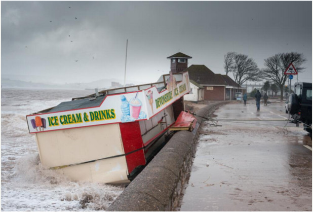
As a rule, the only inherent dangers in promenading and eating an ice cream are seagull attacks and a spike in your delicious waffle cone calorie intake. Recent severe weather conditions and tidal/storm surges have however caused all manner of chaos across the UK, and uprooted some unexpected risks. Flooding in Somerset and the North-East still persists and is having direct impact on quality of life and property with no sign of abating.  While many people are suffering in, frankly, dreadful conditions a small story (but no less terrible) caught our interest:

Exmouth sea front is a 2km stretch of sand dunes, small nature reserves and an award-winning beach.  As with all the best UK beaches it also hosts fish and chip shops and a most excellent ice cream kiosk…up until a few days ago.


Severe winds and erosion of the sandy beach displaced the entire kiosk, causing a potential hazard to shipping. Emergency work was quickly carried out to dismantle the kiosk and, in the process, an alarming discovery was made. Unexploded ordnance, thought to be a smoke grenade (used in military training exercises from around 20 years ago), was discovered under the kiosk.

It’s a bit of a leap of logic but military training in the Exmouth area is well known locally.  Lympstone barracks are less than 5km away from the town and Straight Point rifle range is only 3km along the coast.  Could it be that a training exercise on Straight Point or at Lympstone lead to the grenade falling into the sea? Could the canister have travelled on the tides only to end up washed onto the beach like some sort of weaponised message in a bottle?

Regardless of how it ended up there what this highlights is the often unforeseen consequence of storms, flood and past land use.

The team at LandmarkInformation Group can help you identify areas of both potential flood risk, as well as land used by the military in and around your property area with our extensive analysis of historic mapping - over 10,000 areas of military land identified over a range of mapping from the 1850s up until the early 2000s.  

Daniel Lewis-Carter is Data Information Co-Ordinator at Landmark Information Group.

Tuesday, 18 February 2014

Landmark Information Group launches social housing heat maps

Landmark Analytics extends property market data to provide social housing density analysis for urban or property studies

Landmark Information Group, the UK’s leading supplier of digital mapping, property and environmental risk information, has today announced the unveiling of new social housing heat maps that highlight social housing density by postcode or region, at a glance. 

Via the Landmark Analytics division, the heat maps have been launched to provide an additional layer of data insight into the concentration of social housing property, as well as view average prices, crime information and ‘£ per sqm’ heat maps. 

Managing Director, Selwyn Lim of Landmark Analytics said: “Our aim has always been to find new and innovative ways to equip our users with key property data and so today’s announcement strengthens this.  The social housing heat maps will be of interest to a wide range of different users, from social housing organisations through to developers, local authorities or urban planners who are undertaking analysis of towns, boroughs or property density in general.”

Drawn from various data sources, the social housing heat maps will provide Landmark Analytics clients with access to data from across England and Wales. This freely available new addition to the Landmark Analytics product suite provides users with an overview of where social housing properties are clustered.  Users can type in the postcode of their area of interest, and navigate their way around, viewing the distinct differences in areas, and utilising the colour-coded key on to calculate percentage rates.

The accuracy and breadth of Landmark Analytics’ property database, which is used by HMRC, and in models approved by Fitch Ratings and Standard & Poor’s, supports housing officials with verifying and maintaining the overall quality of their internal records.  The Landmark Analytics database includes a wealth of data including 90 million property images, 20 million sold price records, 18 million historic estate agency listings, 3 million floor plans, plus bedroom numbers, estimated internal area and Council Tax banding information.

In addition, Landmark Information Group provides a wealth of consultancy, data and mapping services, including simple, online GI mapping solutions that enable housing providers to instantly identify areas of risk, visualise essential business intelligence and deliver significant efficiencies and improvements.


For further information visit www.landmarkanalytics.co.uk