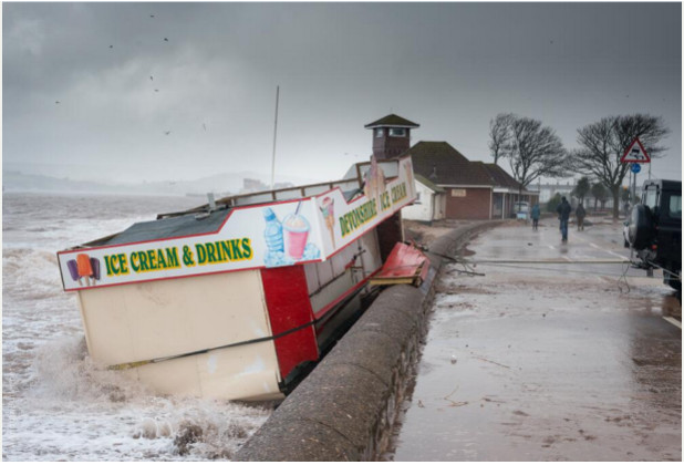
Exmouth sea front is a 2km stretch of
sand dunes, small nature reserves and an award-winning beach. As with all the best UK beaches it also hosts
fish and chip shops and a most excellent ice cream kiosk…up until a few days
ago.
Severe winds and erosion of the sandy beach displaced the entire kiosk, causing a potential hazard to shipping. Emergency work was quickly carried out to dismantle the kiosk and, in the process, an alarming discovery was made. Unexploded ordnance, thought to be a smoke grenade (used in military training exercises from around 20 years ago), was discovered under the kiosk.
It’s a bit of a leap of logic but
military training in the Exmouth area is well known locally. Lympstone barracks are less than 5km away
from the town and Straight Point rifle range is only 3km along the coast. Could it be that a training exercise on
Straight Point or at Lympstone lead to the grenade falling into the sea? Could
the canister have travelled on the tides only to end up washed onto the beach
like some sort of weaponised message in a bottle?
Regardless of how it ended up there
what this highlights is the often unforeseen consequence of storms, flood and
past land use.
The team at LandmarkInformation Group can help you identify areas of both potential flood risk, as
well as land used by the military in and around your property area with our
extensive analysis of historic mapping - over 10,000 areas of military land
identified over a range of mapping from the 1850s up until the early 2000s.
Daniel Lewis-Carter is Data
Information Co-Ordinator at Landmark Information Group.


No comments:
Post a Comment