
Free mobile app launched from Know Your Flood Risk aims to help homeowners, property purchasers and professionals quickly identify potential risk
With the Met
Office predicting wetter-than-average conditions for December and January, and
many parts of the UK recovering from the arrival of the recent ‘weather bomb’
gales, the team at the Know Your Flood Risk campaign has announced the launch of a
free-to-download Flood Risk mobile app to help individuals quickly assess
whether they are at potential risk of flooding.
With the
government pledging to publish more flood-related information to the wider
public to improve the quality of public-focused services, the Flood Risk app,
which is available to download from iTunes, provides an accurate view of current flood risk, using a range of data
sources.
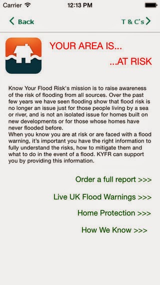
The app lets you
input your postcode, where it will immediately assess the potential risk of
flooding within a 25m zone of the given location. The data is taken from Landmark Information
Group’s ‘Know Your Flood Risk®’ report, which uses current data sources from National Flood Risk Assessment (NaFRA), the Environment Agency and surface
water flooding data from JBA risk management.

Mary Dhonau, Chief Executive of the Know Your Flood
Risk campaign said: “Having been flooded on several occasions, I can personally
vouch that being flooded is an absolutely appalling experience! Flood risk is
not an issue just for those that live by the sea or near a river, but can
affect homes as a result of surface water flooding, which many people don’t
expect or plan for. I therefore urge
everyone to take a look at the app so they can instantly see whether they may be
considered at risk. Forewarned is
forearmed, therefore if you fully understand your risk, you can plan prepare and take moves to protect against it.”
As well as
providing a mapped view of a location’s flood risk, the Flood Risk app also
provides access to live UK Flood Warnings from the Environment Agency, in
addition to access to a free ‘Homeowner’s Guide to Flood Resilience’. This
Guide offers practical advice on how homeowners can prevent and protect their
home from flooding. It is also possible for users to purchase a detailed Flood
Risk Report via the app, should they require a more detailed analysis of their
home’s flood risk.

According to the
Environment Agency, approximately 5.2 million properties in England – which
equates to on one in every six properties – is at risk of flooding. Of these, 2.4
million properties are at risk of flooding from rivers or the sea, while a further
2.8 million properties are considered vulnerable to surface water flooding.

To download the
app, click on: https://itunes.apple.com/app/id941612469


.jpg)
.jpg)


